Click on any image for a larger view
Fox Glacier
 |
| Fox Glacier cave |
Today, our road takes us between two huge lakes, Lake
Wanaka, the fourth and Lake Hawea, the ninth largest in New Zealand. We are actually driving along the opposite
end of Lake Wanaka from where we were shooting this morning. Both lakes lie in their own glacial valley in
the Southern Alps.
We drive up another glacial valley, stopping for photos,
we follow a track (trail) densely lined with ferns, berries, lichens, and moss-covered trees. Our group splits up, each
finding their own favorite subject to photograph. Ultimately, we end up at the end of the path
viewing a towering, but small waterfall.
Continuing towards our destination, we finally emerge on the
west side of the island, viewing the Tasman Sea. The landscape to the west, along the coast is
flat; looking east, the landscape quickly changes to foothills leading to the snow-covered
Southern Alps with 16 peaks over 9,800’.
Mount Cook is the tallest at 12,218’.
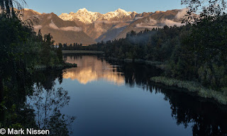
 |
| Matheson Lake |
Arriving at the town of Fox Glacier we learn tomorrow’s check
in time for our tour is 815. On to Lake
Matheson. The track around Lake Matheson
is 2.7 miles long. It is famous for
striking mirror-like reflections of Mount Cook and the Southern Alps. Our hike starts slow, stopping every few feet
shooting the amazing flora. We soon
realize, at this rate we won’t finish our hike until late tonight. Picking up the pace we come to the first
overlook of the lake, my jaw drops at the scene. We understand why this is a must-see
location. I have not seen a lake this
large with such mirror-like reflections.
The track leads to several overlooks providing different views of the
Southern Alps. We arrive at the last
viewpoint 7 minutes before sunset, catching the last of the sun on the peaks. The platform is filled with photographers,
all with the same idea.
 |
| Matheson Lake |
Our alarm wakes us early to be ready for breakfast, then the
walk downtown for our helicopter flight and hike on the Fox Glacier. Even as we arrive our tour is
questionable. Rain, heavy rain, is
forecast for later this evening, but winds are the main concern. We watch videos, listen to instructions on
what to do, then get socks, boots, rain pants and parkas. Up on the landing spot we will be given
crampons allowing us to negotiate the ice. For us, this
is a minimal equipment trip, no backpack, or tripod. If you want to bring a second lens it better
fit in your pocket.
 |
| Our walkway |
Multiple guides have different tasks to take care of each group of trekkers. A lead guide, a second
guide towards the rear makes sure no issues come up. Several others are chopping ice, smoothing
the trail or cutting steps into the ice.
Ropes are placed to assist us to negotiate the ice at several
locations. Here the lead checks the
stability of a long, two-foot screw. It
is screwed into the glacier, anchoring the rope 'railing'. It gets moved if it is not secure. Our second guide mentions that during the
summer, these screws are checked and moved every hour. The sun warms the screw, melting the ice, melting
can be so severe that the screws can be pulled out of the ice by hand.
 |
| Into the crevasse |
As we trek, we learn that the Fox Glacier is receding at a
rate of 330’/year. The life of a
snowflake that falls on the glacier this year, is an average of seven years,
when emerges as water flowing from the other end. Average precipitation in this part of the
world is 19 – 26’ (yes, feet). We see artistry
in the glacier, lines of dense blue ice swirl through the less dense white
ice. Lines of dark colored debris,
pebble-sized to large stones form dark bands in the snow. A small ice cave, four feet tall by six feet
wide holds a chest-deep pool of water.
We follow steps carved into a crevasse, arriving at the bottom, we are
15’ down from the top edge. At the end of
the crevasse, is an ice cave large enough that we can enter. We are surround by organic and ghostly shapes
of remaining glacier where water has flowed.
 We return down the man-made trail on the glacier. Nicida and I compare notes on how our tour is
going. We have enjoyed it immensely,
again, time passes too quickly. We
realize we have not felt cold during our past two hours while here. The heavy boots and socks provided by the
tour company works well along with our thermal tops and bottoms, fleece lined
pants, rain pants, two layers on top, under an insulated coat and raincoat,
hat and gloves. Light rain begins as
each group rides the helicopter down to the landing pad. We ride a bus back to town, it is warm and
sunny off the glacier, at a much lower elevation. We change back to our normal clothing then heading
to lunch.
We return down the man-made trail on the glacier. Nicida and I compare notes on how our tour is
going. We have enjoyed it immensely,
again, time passes too quickly. We
realize we have not felt cold during our past two hours while here. The heavy boots and socks provided by the
tour company works well along with our thermal tops and bottoms, fleece lined
pants, rain pants, two layers on top, under an insulated coat and raincoat,
hat and gloves. Light rain begins as
each group rides the helicopter down to the landing pad. We ride a bus back to town, it is warm and
sunny off the glacier, at a much lower elevation. We change back to our normal clothing then heading
to lunch.
 |
| Fox Glacier View |
Weather dictates our afternoon and sunset
activities. Heavy rain, six to eight
inches, is forecast this evening into tomorrow.
Being a rain forest, this is normal.
After lunch we reconvene, deciding to head out to the Fox Glacier
Viewpoint where we get a view of the glacier flowing down the valley, we hiked earlier today. The clouds clear just
enough for us to see Mount Cook and Mount Tasman. After a short time, a large tour bus arrives
with camera toting Asian tourists out to photograph the same view we have been
shooting. A few minutes later a second
bus arrives. Quite the popular place.
Returning from dinner, a light drizzle begins, which turns
into wind-driven rain we hear throughout the night. It is still raining the next morning, as we
bring our bags down to the van, and as we are leaving for our next
destination. Steve informs us we
received four to five inches of rain overnight.
We were blessed with good weather yesterday, there will be no glacier
touring today.
Today we will be driving most of the day, partly because
it’s a long distance, and partly because of the weather. If it is not raining, it is snowing. Snow shows up in the two high passes we must
travel through to get to our destination.
Last night we could see Mount Cook from the Fox Glacier Viewpoint. It is only 18 miles, as the crow flies, from
the town of Fox Glacier to Mount Cook.
It is 243 miles by road.
 |
| 1/30 of a second creativity |
As I stare out the window during our ride to Mount Cook, I have a flash of creativity. I start shooting long exposure images of the flora whizzing by our window. When we are on our road trips in the States, I am driving half the time and paying attention the other half. Here I am enjoying the ride. It is hard to tell what I am getting on the camera's two-inch screen, so I don't see the images until we get home. Some are good others, not so much, but it is a worthwhile experiment.Approaching Haast Pass we come into the first snow. Big fluffy flakes slow us down a bit, but it
passes as we descend on the other side.
The quiet flowing rivers we saw two days ago, are torrents from the
deluge of water. We stop in Wanaka for
lunch, a little better than halfway to our destination. Heading on towards Twizel, we start ascending in elevation. Rain turns to snow. It becomes heavier as we ascend to Lindis
Pass, the brown landscape turns white.
Steve follows a large truck breaking the way on the 2-lane snowy, slushy
road. We notice trucks and buses going
in the opposite direction stopped in the middle of the road. Descending, the snow becomes lighter, turning
back to rain. Once in Twizel, Steve
admits to us that he was not certain we would have made it through the pass
without the large truck in front of us.
We learn later that the road through Lindis Pass was closed one-hour
after we passed through, due to the snow.
We stay in the hotel for the evening having our dinner near the
fireplace with a warm, crackling fire.
 |
| Lake Pukaki |
We are on the road for a sunrise shoot at Lake Pukaki. Clouds are low so we are not expecting a
colorful sunrise, but one has to be out there in case it shows up. We hike over a rock field to get to our
spot. Rocks of many sizes and shapes continue
into the water providing us foreground subjects for the distant shoreline. Polarizer filters allow us to modify the
extent of the reflection of the water allowing us to ‘see into’ the water. Yesterday’s precipitation is a blanket of
snow on the higher elevations of the mountains.
We can see a definite line where the snow and rain intersect. At times the clouds and white blanket of snow
blend, so that we cannot decipher which is which.
Church of the Good Shepherd
 |
| Church of the Good Shephard |
We head off to Lake
Tekapo to see Church of the Good Shepherd.
This is another popular photographer location, much like the Lake Wanaka
Tree, mentioned earlier. We can tell we
are getting close; the line of cars gets longer and slower, and the number of
tourist buses grows. We grab our cameras
and tripods hoping the throng of tourists dissipates enough for us to shoot the
church by itself. Patience pays off
under these conditions.
After shooting the church, we head off towards coffee shops/bakeries
for some sustenance, coffee for Nicida, tea or hot chocolate for me. I want to caution you; the rest of the
paragraph may be disturbing. As we are
waiting, I need to use the bathroom, while on this trip we learn that both
Australia and New Zealand have very modern public bathrooms. There are lights red/green indicating whether
it is occupied or not. Push the button,
the door opens, enter, push another button, the door closes – all well and
good. A few seconds later a voice
notifies me “You have 10 minutes.” I
immediately wonder…. ‘What happens if I
am not done in 10 minutes?’, ‘Do alarms
go off?’, ‘Does the door open to armed officers?’. I make sure I am not there to find out. Nicida tells me that the one In Melbourne
says the door will not open to let you out until you wash your hands… As my mind wanders on this topic - HAL from
2001: A Space Odessey, comes to mind.
‘Open the bathroom door HAL’, ‘I’m sorry Mark, I'm afraid I can’t do that.’
Mount Cook
 |
Approaching Aoraki/Mount Cook
National Park |
This afternoon and evening we head off to Aoraki/Mount Cook
National Park. The mountains grow, then
surround us each kilometer we continue into the park. The foothills are wearing the browns of
winter. As the road take us higher, we
see snow hiding in the shadows of shrubs.
Ascending even more, patchy snow covers the ground. Above us, on the mountains we see the line of
demarcation, where brown ends and white begins.
Our little group splits up, there are seven of us in the adventurous
group, the hike to the top of the hill group.
We head off on the Tasman Glacier View Track. The track is three quarters of a mile, one
way, more importantly there are 339 steps to get there. We start out at a good pace, but part way up
we pass that line of demarcation, crossing into ice and snow. Unfortunately, the steps and trail are the
ice part, the snow part is off-trail, hilly, steep, and brush covered. Gary reports this is the first time he has
ever hiked this trail with ice. This
would be a good time to have crampons.
The other five of our group forge ahead, Nicida and I take our time
testing each step.

 |
| Aoraki/Mount Cook sunrise |
The next morning, we are on the road by 7 to catch a sunrise
of Mount Cook over Lake Pukaki. Multiple
layers of clouds allow us to see the crest of Mount Cook but filter the sun
from a colorful sunrise.
Returning to the hotel, we check out, preparing for our
return to Queenstown for one more day of our workshop. As we approach Lindis Pass the snow which we
experienced on the way to Twizel is still here.
The smooth, white blanket of snow has warts; small plants supporting the
snow. The car park, (parking lot) is
full of visitors slipping and sliding across the snow-and ice-covered pavement for
photos and selfies. We join in.
Queenstown
Arriving at Queenstown we check into the hotel, meeting
later for our last sunset shoot, and Milky Way shoot, if the conditions are
right. To this point, the clouds have
not cooperated any of the nights we have been here. Tonight is our last chance.
We head off to a small lake to catch sunset on the
surrounding mountains. Calm conditions
give us mirror-like water again. Each
of us take off in a different direction guided by our vision. Before dark, we pack up heading back to Lake
Wakatipu for a spot to shoot the Milky Way.
The mountains on the far side of the lake are still light enough for us
to see. We aim and focus on either the
stars that are visible or lights on buildings a few miles away.

 |
The last sunrise of our
workshop |
As we get into the van the next morning, we are greeted by
clouds and 29°. We head back to
the same spot we enjoyed our spectacular sunset, the first evening we were
here. This time the clouds allow us to
see the lower portion of the mountains, while obscuring the peaks. We see portions of the mountains light up
while at the same time the clouds lower, obscuring even more. We call it a day.
We return to the hotel, happy but exhausted from a busy
workshop. We say our goodbyes to
everyone. Several are leaving for the
States this afternoon. Others leave tomorrow,
Nicida and I are here for two more days before heading on to Auckland.
It was a fantastic workshop; we recommend signing up for
one. We learn more each time we attend, the
attendees are open to learning more, and we get to go to spectacular places at
the best times to see and shoot.
Thank you for stopping by,
Mark


 We return down the man-made trail on the glacier. Nicida and I compare notes on how our tour is
going. We have enjoyed it immensely,
again, time passes too quickly. We
realize we have not felt cold during our past two hours while here. The heavy boots and socks provided by the
tour company works well along with our thermal tops and bottoms, fleece lined
pants, rain pants, two layers on top, under an insulated coat and raincoat,
hat and gloves. Light rain begins as
each group rides the helicopter down to the landing pad. We ride a bus back to town, it is warm and
sunny off the glacier, at a much lower elevation. We change back to our normal clothing then heading
to lunch.
We return down the man-made trail on the glacier. Nicida and I compare notes on how our tour is
going. We have enjoyed it immensely,
again, time passes too quickly. We
realize we have not felt cold during our past two hours while here. The heavy boots and socks provided by the
tour company works well along with our thermal tops and bottoms, fleece lined
pants, rain pants, two layers on top, under an insulated coat and raincoat,
hat and gloves. Light rain begins as
each group rides the helicopter down to the landing pad. We ride a bus back to town, it is warm and
sunny off the glacier, at a much lower elevation. We change back to our normal clothing then heading
to lunch.


No comments:
Post a Comment