Click on any image for a larger view
 Our second day’s hike is to the Doe Mesa along Dry Creek
Road. It is about 5 miles west of
Sedona. The mesa itself is about 400’ above the
surrounding terrain measuring about a half mile by a quarter mile at the mesa
top. I could get used to this; having a multitude of hiking trails within a 30 minute, or less, drive from town.
Our second day’s hike is to the Doe Mesa along Dry Creek
Road. It is about 5 miles west of
Sedona. The mesa itself is about 400’ above the
surrounding terrain measuring about a half mile by a quarter mile at the mesa
top. I could get used to this; having a multitude of hiking trails within a 30 minute, or less, drive from town. Each of us is stiff this morning but we know that getting
out for another hike will take care of that.
Each of us is stiff this morning but we know that getting
out for another hike will take care of that.
Since we took an auto tour of the rock formations in the Oak
Creek Village area we arrive at the trailhead after 10. Each parking area we pass for other
trailheads is packed with vehicles. We
end up parking along the road with dozens of other vehicles for our hike of
choice.
 This trail is popular with many families hiking to the
top. The switchbacks go from mud to ice
depending on how much sun reaches the trail.
Sandstone, even when wet, actually grips our hiking boots. This is not the way it works when hiking the
granite in the many mountains of New Mexico.
It takes me a while to trust my footing on the wet sandstone.
This trail is popular with many families hiking to the
top. The switchbacks go from mud to ice
depending on how much sun reaches the trail.
Sandstone, even when wet, actually grips our hiking boots. This is not the way it works when hiking the
granite in the many mountains of New Mexico.
It takes me a while to trust my footing on the wet sandstone.
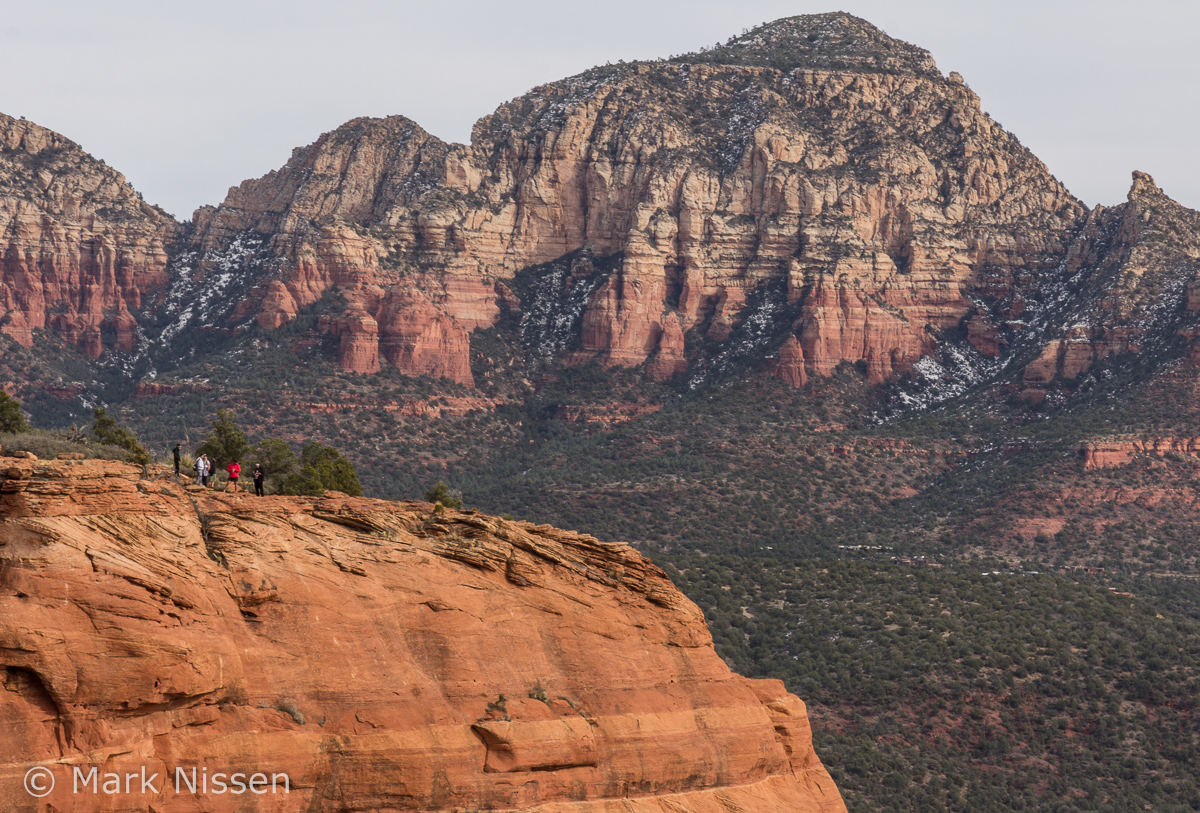 After a 45 minute hike, including many switchbacks, we
arrive at a small slot between rocks leading us to the top. Once on top we pick a route leading to and
around the edge of the mesa. Views from
the precipice are everywhere. As we
stand on one point looking out, awestruck by the view, we see the next point we
have to visit to see if that view is just as good. From here we can see Fay Canyon just a few
miles away. Don tells us about the
canyon; we decide then and there Fay Canyon will be tomorrow morning’s hike
before returning to Albuquerque.
After a 45 minute hike, including many switchbacks, we
arrive at a small slot between rocks leading us to the top. Once on top we pick a route leading to and
around the edge of the mesa. Views from
the precipice are everywhere. As we
stand on one point looking out, awestruck by the view, we see the next point we
have to visit to see if that view is just as good. From here we can see Fay Canyon just a few
miles away. Don tells us about the
canyon; we decide then and there Fay Canyon will be tomorrow morning’s hike
before returning to Albuquerque. As we continue around the mesa we can see back to Sedona and
some of the formations that are familiar from the Brins Mesa hike. We see kids running along the edge of the
mesa stopping just before getting to the edge.
I had this hollow feeling in my stomach seeing kids I don’t even know
looking over the edge. This must be how
parents feel when they see their kids hanging over cliff edges. I couldn’t look.
As we continue around the mesa we can see back to Sedona and
some of the formations that are familiar from the Brins Mesa hike. We see kids running along the edge of the
mesa stopping just before getting to the edge.
I had this hollow feeling in my stomach seeing kids I don’t even know
looking over the edge. This must be how
parents feel when they see their kids hanging over cliff edges. I couldn’t look.
Farther along our hike we could see the encroachment of
multimillion dollar homes at the base of the mesa. It seems each one is several thousand square
feet in size. We were told they are only
used a small portion of each year.
 Some other hikers came upon a lost 10 year old boy. He wandered away from his mom and
siblings. It’s amazing how large a ½
mile by ¼ mile mesa is under those conditions.
He had a walkie-talkie but the batteries were not installed and he had
to guess which channel his family was using.
Planning was good; implementation, not so much. For those of you that want or need to use
walkie-talkies please make sure everyone actually uses them, talking and
listening, before taking off on a hike.
I believe if that had been done before this hike that boy would not have
gotten lost. I’m off my soapbox now.
Some other hikers came upon a lost 10 year old boy. He wandered away from his mom and
siblings. It’s amazing how large a ½
mile by ¼ mile mesa is under those conditions.
He had a walkie-talkie but the batteries were not installed and he had
to guess which channel his family was using.
Planning was good; implementation, not so much. For those of you that want or need to use
walkie-talkies please make sure everyone actually uses them, talking and
listening, before taking off on a hike.
I believe if that had been done before this hike that boy would not have
gotten lost. I’m off my soapbox now. The trip back down the mesa is a little less
treacherous. The ice has turned to a
thin layer of mud, but grippy mud so there was no skating down the rocks.
The trip back down the mesa is a little less
treacherous. The ice has turned to a
thin layer of mud, but grippy mud so there was no skating down the rocks. We hit the Javelina Cantina for dinner. There was some traffic coming into Sedona but
it took only a few extra minutes to get to our destination. Our walking to the restaurant is still a bit
slow but otherwise we all feel pretty good.
I have another beer; everyone else is more daring having
margaritas.
We hit the Javelina Cantina for dinner. There was some traffic coming into Sedona but
it took only a few extra minutes to get to our destination. Our walking to the restaurant is still a bit
slow but otherwise we all feel pretty good.
I have another beer; everyone else is more daring having
margaritas.
As we drive back to Cottonwood the Sedona traffic is lined
up even farther than the previous day.
 No additional laundering is needed to clean the red
sandstone mud from our clothing this evening.
No additional laundering is needed to clean the red
sandstone mud from our clothing this evening.
Tomorrow, on to Fay Canyon.
Thank you for stopping by,
Mark
OOO beautiful views!!! I'm with you, no running toward the edge of any cliffs for this girl, I'd be more likely to crawl and peek over, my fingers clinging onto the dirt. A person must feel very small in the universe when overlooking these sights. gorgeous.
ReplyDelete