Click on any image for a larger view
 |
Grand Canyon, sunset |
Back in early-March we started thinking about a trip to
Greece when the pandemic hit. As time
went on we knew Greece was out of the question so we started looking at
revisiting southern Utah catching some of the areas we missed in April, 2019.
Our Utah trip kept getting revised over the past couple weeks; mostly related to the pandemic. We planned on making several stops in the Navajo Nation. We kept watching the virus updates up to the week before we departed hoping it would reopen, it didn’t happen. National park camp sites always seem to be full especially in southern Utah. I visited the recreation.gov site many times hoping for a site to open. I struck it big finding a site in Zion NP for four nights; it even fit our schedule. I grabbed that one, happy with our luck. Our other big change was bypassing Albuquerque, missing out on visiting our friends. NM has a 14-day quarantine in effect for any out of state visitor. The rules didn’t change when we passed through the state and again on our way home. We will catch up with them next time.
We are taking our cooler filled with meals for four weeks
instead of the seven we did for Alaska. While
the plan worked well we want to improve our technique. Dry ice and packing the meals with better
organization are my main focus. We want
to keep our premade meals: chicken fajitas, chicken ala king, eggplant
parmesan, and salmon, among others, frozen until we want them. It’s quite nice to pull out a prepared
dinner; reheat it, add a salad then dine.
In addition we have several prepared vegetables and breakfasts. As it turns out we ate out only three or four
times during our trip. Our only
challenge was to find dry ice along our route.
 |
| Very Large Array |
We depart with dark rain clouds on the horizon. For the first half of the day we drive
through light rain, heavy rain and no rain.
By midafternoon, in western TX, the clouds have disappeared and mid 90’s
have returned. The green of the hill
country becomes a little more brown and with the flat land agriculture appears;
sorghum, cotton and pecan groves. Along
with the agriculture we see oil being pumped, and along ridges, wind farms are
producing electricity. We also notice
the uniquely ornate courthouses passing through several small towns.
Mesas make their appearance as we cross into NM. Scrub brush covers the land and the sky opens
with wide views. We drop into the Rio
Hondo river valley outside of Roswell on our way to Capitan, home of Smokey
Bear. Unfortunately this is Labor Day
weekend so the place is packed with visitors and campers. We have to leave the cool forest of Capitan
dropping into the valley near Carrizozo to stay for the night. Finding an RV park next to a motel we setup
under a tree and relax, a breeze making the afternoon very comfortable. After dinner we walk from one end of
Carrizozo to the other. As the sun sets,
wildlife comes alive. We spot and hear a
great horned owl perching on posts and in trees, alert for dinner. The only drawback to this location is the 5 –
6 trains that passed by throughout the night on the tracks on the opposite side
of the road.
Very Large Array
 |
| Petrified Forest National Park |
Petrified Forest National Park
 The park has two entrances making it a drive through park. The road through is 20+ miles long with many
viewpoints and trailheads. The park is
only open during daylight hours. We
arrive shortly before closing so we hit the Giant Logs trail near the south
visitor center. The shop inside the
visitor center is open but the exhibits are closed. A park ranger located outside answers any
questions we have about the park supplying us with suggestions regarding the
best trails and viewpoints given the limited time we have. We find that all the National Parks on this
trip operate the same way; shops open, exhibits closed, and a ranger to answer
questions. Talking with one of the park
personnel we find visitation here has been about 40% of normal.
The park has two entrances making it a drive through park. The road through is 20+ miles long with many
viewpoints and trailheads. The park is
only open during daylight hours. We
arrive shortly before closing so we hit the Giant Logs trail near the south
visitor center. The shop inside the
visitor center is open but the exhibits are closed. A park ranger located outside answers any
questions we have about the park supplying us with suggestions regarding the
best trails and viewpoints given the limited time we have. We find that all the National Parks on this
trip operate the same way; shops open, exhibits closed, and a ranger to answer
questions. Talking with one of the park
personnel we find visitation here has been about 40% of normal.


 |
| Blue Mesa |
The wind persists through the night and into the next day as we
depart Holbrook for the north rim of the Grand Canyon. Many of the people at the RV park pulling
trailers or driving large motorhomes decline to battle the wind. Winds have never bothered us given the small
profile of our popup camper. We cannot
tell where the haze ends and the blowing dust begins as we travel north of
Flagstaff. Once we cross the Colorado
River just south of Page, AZ, the mountains near Flagstaff are shadows against
the hazy sky. Passing the Vermillion
Cliffs then climbing up the Kaibab Plateau we are back into forest. Forest roads leading north of 89A are closed,
we find out later that the area was evacuated just over a month ago due to wild
fires. Jacob Lake campground was only
recently reopened. Our reservation for
the north rim campground was cancelled only a few weeks earlier due to failure
of one of the water pumps bringing water to the north rim. We are not certain if and what camping we
will find. After speaking with the camp
host at Jacob Lake, about 30 miles from the North Rim entrance we find out
there are open sites at Demotte campground only five miles from the park
entrance. Demotte campground is nice, we
find a site, set up, and have eggplant parmesan for dinner. The wind is still blowing as we walk the
campground. We find maps of the north
rim, and study them intently figuring out tomorrow’s plan of action. Cold temperatures are expected overnight; mid
20’s. We zip together our two sleeping
bags adding a fleece blanket in preparation for the cold.
Painted Desert
Grand Canyon National Park – North Rim
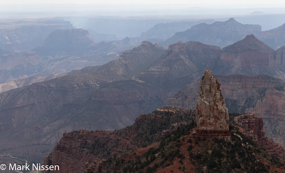 |
| Point Imperial |
The truck thermometer says 33.
Heading off to the Grand Canyon we notice the wind has stopped. The road to the park passes through open
meadows, pine forests and skeletons of pine trees still standing after a long ago wildfire. Once in the park we take the turnoff to Point
Imperial and Cape Royal, 15+ miles from the main road. The view from Point Imperial is amazing. We are able to see the Vermillion Cliffs rise
above the valley, these are the same cliffs we had driven along to get here. We see a long narrow gash in the earth widening as it flows to the southwest,
the start of the Grand Canyon. We were
told the view from the north rim is very different than the south rim. The north rim is a long way from the Colorado
River so we see many feeder canyons leading to the Colorado. From the south there is more of a vertical
drop from the rim to the Colorado. It is
quiet here; no vehicle noise, no jet noise, people stand in awe of what they
are seeing not able to talk. It is not
crowded; we see maybe 20 people the time we are here.
Angel's Window
The views from Cape Royal are equally stunning, with different formations
to contemplate. We get a small glimpse
of the Colorado River a small blue-green stripe at the bottom of the canyon surrounded
by miles of red rock.
Cape Royal
 |
| Bright Angel Point |
The visitor center at Bright Angel Point is closed. A park employee gives us a small piece of paper with the date and ‘official’ Grand Canyon cancellation stamp. No Grand Canyon stickers for our passport books are available, we have order them online. We order food at a bar/restaurant picking it up at a take-out window across the courtyard. Only 1/3 of the many tourist cabins are available, the pandemic and water pump issue mentioned earlier limiting the occupancy. Even with these limitations we see a few hundred people enjoying the views, picnicking and hiking. We can see where the main channel of the Grand Canyon is but there are too many formations blocking our view of the river itself. The haze comes and goes, but there is always some haze present. We drive to the Widforss trailhead, a possible hike enabling us to see the Grand Canyon from yet another viewpoint. We spot a sign for Point Sublime. I have read of Point Sublime in my research but did not pursue it, thinking it is a point far removed from the main park. Finding this piques our interest for another off-road adventure.
 |
| Bright Angel Point |

Angel's Window 
Bright Angel Trail -
lower portion of image
 |
| Cape Royal |

Cape Royal 
Cape Royal

 |
| Cape Royal |
Our return drive takes almost an hour. Many deer are out having dinner. By the time we arrive the Milky Way is out,
easily spotted with the naked eye under the dark skies.
The next morning we study the map for Point Sublime, we reread the
instructions with mile markers called out for turns and splits in the
road. We have two Garmin GPS units. One for the truck and the one for
emergencies. Both have displays so we
have a good idea of roads and turns. The
first several miles are gravel forest roads in various conditions. Continuing further the road becomes a two
track with very few turnouts making us wonder what we will do when we come upon
someone traveling the opposite direction.
The unnerving part came when both of the GPS units went blank - no
roads. They are still tracking us but on
a blank screen. After 20 minutes of
blank screens roads start reappearing with names of the roads we are
expecting. Almost two hours into our
trip, about a half mile from our destination we see the first people since we
started our expedition. Fortunately the
road is wide so we can easily pass. They
were awestruck by the view “It was worth the drive”. Five minutes later we arrive at Point
Sublime.
Point Sublime
We step out of the truck to
a spectacular view of the canyon. We cross
to the opposite side of the point seeing an equally spectacular but totally
different view. Then we walk out to the
point putting everything together, a 270° panorama of the Grand Canyon. It is breathtaking. There are only a handful of people here to
view this spectacle. We shoot images,
stop to take in the view then shoot some more.
We spot a small piece of the Colorado River. Two families are camping up here. To camp one needs a backwoods pass, and a
reservation. From their description it
is not something one easily obtains.
After the excitement of viewing the canyon from this viewpoint we settle
down for lunch, enjoying the view. We
face the inevitable, we have to go back.
We are thrilled at finding this place; first - that we even found out
about it and, second - that we are able to make it here. A return trip with an overnight stay is
definitely on our list of things to do.
Point Sublime
We meet two other vehicles during our two hour return.

Cape Royal 
Cape Royal
Finding a dispersed campsite for the night we make ourselves
comfortable. The next morning we have an
emergency; I am not able to light the
stove, our handheld lighter doesn’t want to light. We try our tricks of holding it by the
furnace outlet to warm it, but no luck… Coffee is a necessity. We are a long
way from a coffee shop so I have to come up with something. I hear the water heater burner heating the
water so I look around for some cardboard then head outside. After two or three tries I am able to light
and keep the cardboard lit long enough to get back inside the camper then light
the stove. I’m thankful it isn’t
windy! Disaster averted. BTW we bought an additional lighter, and
matches just in case…
Thank you for stopping by,
Mark
Gorgeous, gorgeous pics!!! Love your narrative. We hit some of the same spots but missed some too. Would love to know where you plan to go next?
ReplyDeleteWe are working on that... Going east on our next trip
ReplyDeleteThanks for sharing the wonderful trip. Hopefully, next time you're in NM we'll get to see you! Esther
ReplyDelete