Click on any image for a larger view
The start
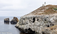 |
| Anacapa Island |
We are back on the road, truck, camper and the open
road. We have three reasons for this
trip. - Nicida’s college friends are getting together to celebrate their 54th
anniversary from college. Their
celebration will be in Sonoma, CA. – We
are escaping the continuous heat of TX. – This will be the swan song for our
camper. We have enjoyed using it for the
past seven years. We have had many great
memories with our Hallmark Guanella. A
small sampling: southern UT three times, a 12-week drive to Alaska and back, 5
of the National Parks in CA. As of this
writing we have seen 39 of the 63 NPs having driven to 35. The others we either had to fly to or take a
boat. At the end of this trip, we will
have visited 42 NPs. You can read all of
our adventures on this blog, just look under the Archive, everything is sorted
by year.
Don’t worry, we are not stopping our adventures. We are upgrading to a larger truck
camper. We won’t be able to go to some
of the remote places we have seen with our Hallmark. Instead, we will able to go out for longer
periods of time and under more extreme temperatures.
We have been cooking like mad for this trip. We ended up with over 30 prepared dinners and
another 20 prepared breakfasts.
Everything is packed and frozen in 1-quart bags, which fit quite nicely
in the camper’s freezer. We are also
taking our heavy duty cooler, packing 18 dinners and several breakfasts keeping
everything in a hard freeze using dry ice.
The dry ice has to be replenished every few days, especially given the
80 – 90 degree heat we will be facing.
In all, between the two freezers we have 24 dinners and 15 breakfasts.
On the road
It is already humid the morning we start our final
packing. On the road, we see the
evidence of the wet spring and early summer. Plants are looking healthier than when we left
on our trip last year at this time.
Roads are clear of traffic.
Approaching Abeline the winds pick up, windmills are spinning, producing
electricity. We are staying in a hotel
tonight. It’s too hot to stay in our
camper, without air conditioning.
 |
| High Desert RV Park |
Our next stop is Albuquerque, our old stomping grounds. A few friends are available for lunch or
dinner, it turns out to be a weekday, so many are at work during our short
stay.
While we are on the road, I am having challenges getting my
new iPhone working. My old one died two
days before we left on this trip. I
scrambled to get an iPhone 15 before leaving.
Because the old one just died I was not able to transfer all the data to
the new phone. After several calls to
Apple I have everything but my primary email account working. I went online calling the first ‘Apple’
support number – you may see where I am
going… I spoke with a gentleman for
several minutes being convinced that I have only one more opportunity to get
everything working or my new phone will be locked out. It will ONLY operate as a phone, no email, no
texting. Period…. But he can help me – just go out and buy an
Apple gift card for $200.  They will take
the number off the card to verify I am who I say I am then they will be able to
get my phone, with email up and running, then I will be refunded the $200. Nicida and I looked at each other
thinking… The ‘apple’ guy provides
directions to the closest store where we can purchase an Apple card, very
helpful. At the Walgreens counter we
tell the cashier we want to buy this card, the little screen where you place
your credit card to make the payment pops up a warning about scammers. We stop right there, walking out of the store. Speaking with the ‘apple’ guy again, he tells
us a very prepared story about how the phone will no longer work. We hang up.
Scam averted. The next day I
speak with a real Apple support person getting my email account back online,
all is still well.
They will take
the number off the card to verify I am who I say I am then they will be able to
get my phone, with email up and running, then I will be refunded the $200. Nicida and I looked at each other
thinking… The ‘apple’ guy provides
directions to the closest store where we can purchase an Apple card, very
helpful. At the Walgreens counter we
tell the cashier we want to buy this card, the little screen where you place
your credit card to make the payment pops up a warning about scammers. We stop right there, walking out of the store. Speaking with the ‘apple’ guy again, he tells
us a very prepared story about how the phone will no longer work. We hang up.
Scam averted. The next day I
speak with a real Apple support person getting my email account back online,
all is still well.
The next day we are on the way to Williams, AZ. Being at high elevation the weather during
the day is pleasantly cool. We find an
RV park with electricity for the night. We
speak with Joe and Cindy, fellow campers.
We compare notes on upgrades each of us has done to our campers. Joe has many more ideas than I, mainly having
to do with bungee cords. Each is great,
I am looking forward to getting back home to employ some of his ideas.
Grand Canyon Steam Train
The railroad track for the tourist train traveling to the
Grand Canyon runs behind our campsite.
As a special treat, a steam locomotive is actually pulling the cars on
this day. Normally, it only runs the
first Saturday of each month, rather than a diesel engine. (A note to you train enthusiasts.) As the temperature drops to the 40’s we are
glad to be in a campground with electricity so we can use the space heater
brought from the house to keep us warm and cozy. Unfortunately, the next morning we find the
truck battery dead. A quick jump from
another camper gets us back on the road.
As we progress across Arizona, the temperatures stay cool,
60 ‘s – 70’s. But that changes as we
drop in elevation once we pass Kingman, AZ.
Lower elevation means higher temperatures, back up into the 90’s. Approaching LA I am concerned about the smoke
from the local wildfires in the area.
But we don’t see any on the way to Victorville, CA. 90 degree temperatures means another hotel.
The truck starts normally the next morning. We are off to visit relatives and friends
today, before heading to Oxnard. This is
our first encounter of many, seeing $4.00+/gal gas.
Dropping into LA we see the smoke I was concerned about
yesterday. It is thick, thick enough
that the skies are more gray/brown than blue.
We make our way around LA, slowly at times, at the designated speed
other times. After lunch, I program the
Oxnard apartment address into the Garmin and find out it’s over 100 miles, and two
hours to our destination. I look at the
distance certain that it must be a mistake.
I reprogram our destination getting the same result. It’s going to be a long afternoon.
Channel Islands National Park
Approaching Oxnard, the smoke clears revealing blue
skies. Even closer, the blue skies
disappear, low clouds take their place, the warm temperatures turn to damp 60
degree temperatures. Jacket
weather. After checking in, we ride
around finding where we catch the tour boat to the Anacapa Island, the smallest
island one can tour of the Channel Island chain. We also head into Ventura to find the battery
place to have the truck battery checked and get an assessment. The battery place closed 20 minutes
earlier. We will try again tomorrow.
 |
| Anacapa Island |
The Channel Islands is one of the nine national parks in
California. There are a total of eight
islands scattered along the California coast in Channel Islands National Park. Four are grouped close together, with the
Island Packers providing NPS regular tours of the four islands. Tours go each day but not to every
island. The closest island is 13 miles
from the coast. We are interested in
Anacapa because it can be easily hiked in a day. The other islands are larger, each several
miles wide and long. Camping is allowed
on each island but you have to bring everything with you, including water, and
everything you bring, has to be carried back out.
The islands are totally separate from the continent. With the exception of what humans have
brought to the islands, the flora and fauna are unique, found nowhere else on
earth. Excavations of the islands have
shown that native peoples have been on these islands as far back as 13,000
years. Now the islands are protected as
a National Park and the waters extending out six miles from each island are
protected as National Marine Sanctuaries.
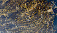 |
| Kelp |
We are up at 6 AM packing cameras, food, water, jackets and
sunscreen. We are not certain what to
expect. We were told by the tour guides
last evening that the islands can be in bright sunshine, or under a heavy, gray
blanket of clouds. Stepping outside our
apartment we are greeted by light mist from the dense clouds overhanging the
coast. We get our boarding pass and
return pass, used to track that everyone that is scheduled to return is
actually on the boat. We head out to the
beach to watch a dozen surfers ride the waves.
Sand Pipers dash up and down the shoreline, running from the waves as
they come in, following the waves, looking for a meal, as the waves recede. The taller ones have the advantage, not
having to run quite as far or as fast as the shorter birds.
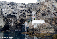 |
| Anacapa Landing |
We make several stops where our guide describes different
aspects of the island; flora, fauna, geology, inhabitants. Now, it is a sanctuary to all the flora and
fauna. Even now, work is going on to
remove non-native plants that were brought to the island for the sheep that
were once raised here. We stop at
several locations where we have spectacular views of the ocean crashing below. We can hear seals barking over the sound of
the crashing waves. Our guide informs us
that this is a good time of year to visit, all the baby birds have fledged so
those remaining are not protective of their nests. She demonstrates to us how we would have to
constantly cover our heads with our hands and arms to protect ourselves from
protective parents.
The official hike/tour finished, we stop for lunch then
wander around the island for the views and a few more photos. We do not want to miss the 330 boarding time. Today the water is smooth in both directions allowing
us to enjoy the ride. We arrive back in
the harbor then decide to visit the official NPS Channel Islands Visitor
Center. Afterwards we pick up dinner
then head back to our room, worn out from the day-long trip. Tomorrow we will get the battery checked,
then on to Pinnacles NP.
It is cloudy, with occasional mist as we start the day. Heading up to the Interstate Battery shop we
find it open, and nobody in line. We
drive right up, explain our problem and the service man pulls out the hardware
he needs to check the battery. He
determines that the battery does indeed need to be replaced. Fifteen minutes later we are back on the
road. All is good.
The road all the way to San Luis Obispo is covered by heavy
shapeless gray clouds. It never gets
above the low 60’s. We climb up through
the Questa Ridge, descending on the other side, the skies clear – no clouds in
sight – and mid-70 degree temperatures.
Progressing north, large scale farming continues; strawberries,
tomatoes, and broccoli, to name a few.
Vineyards grow in size, wrapping around hills. When looking at the distant hills, along the
rows of vines I am reminded of corduroy pants, raised fuzzy rows next to low
clear rows. Traffic greatly falls off as
we exit 101, towards Pinnacles NP. We
make one more stop for gas, it keeps increasing in price as we continue our
trip, this time $4.34/gallon. The terrain
changes again with small rolling hills covered by golden, dried grasses. Lonesome green trees are scattered among the
rolling hills. Here the road follows the
terrain, not like 101 where the land is recontoured for the road.
Pinnacles National Park
Arriving at Pinnacles NP we really don’t see any difference
in the landscape. We silently wonder
what is special about this park. Meeting
one of the park volunteers we learn what makes this park special. Only a small area of volcano driven terrain is
at this location. A portion of it is
still down around northern Los Angeles where the volcano erupted 23 million
years ago, near present-day Lancaster CA, 195 miles southeast of where we are. Diving into geology, plate tectonics in
particular, a portion of the volcano was/is on the American Plate, which is
slowly moving south. The Pinnacles part
of the remaining volcano was/is on the Pacific Plate which is moving
north. The pinnacles are a combination
of lava, granite, and a conglomeration of rocks glued together by pumice and
soil. We see as we hike on the pinnacles
we are surrounded by sedimentary rock which has eroded, becoming the smoother,
rolling hills we saw as we drove here.
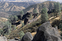
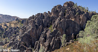
The bald peaks of the Pinnacles are a stark contrast to the
rolling hills we saw all around us on our drive to the park. Tomorrow we will hike the ‘High Peaks Trail’
and the strenuous ‘Condor Gulch Trail’ to see the peaks close-up.
Overnight we have a hard time sleeping. We are not used to sleeping in 40°
temperatures. Our fleece blanket and
lightweight sleeping bag are not enough to keep us warm, serious cuddling went
on conserving body heat. Waking the next
morning we turn on the camper’s furnace, leaving it on a few minutes, taking
away the chill. Afterward, I head out to
the park bathroom. As I walk across the
open field I spot 40 black/brown bocce balls setting randomly in the field. As I am trying to reason why these bocce
balls are there, a few of them start moving by themselves. This is even more startling. Then, looking closer there are 40 quail that
were sitting, probably watching me, before they took off. Quite the scene.
'Bocce Balls'
We are on the Condor Gulch trail by 930. The sun is already busy heating the
rocks. No clouds to help buffer the
heat. This trail takes us up 1,500’ in
2.5 miles. By the time we get back to
the camper we put on over five miles.
 |
| A Jay's Pantry |
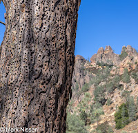
Pinnacles is one of the parks where condors were reintroduced to the
wild, after becoming almost extinct.
They are seen here quite regularly, this trail in particular. As we ascend, taking in the beauty of the
rocks themselves we see birds soaring high above us. Nicida pulls out her camera snapping a few
images, both of us are certain they are condors. The rocks making up the pinnacles are
combinations of granite, lava and a conglomeration of rocks glued together by
pumice and mud. We continue to the peaks
looking across at rocks jutting out of the ground and others seeming placed in
that specific location. At the very top
of the trail the CCC worked on cutting steps into the rock itself and placing
piping as handrails assisting us on our climb.
As afternoon wears on we start our descent back to the truck. We feel the cool of the trail blocked from
the sun. We also feel the heat radiating
at us from below where the sun has been beating on the rocks all day long. We would not want to be here during the
summer.

We stop at the visitor center to show images of the birds,
hopefully condors, Nicida shot. One of
the park service bird experts looks at a few of her images, “Turkey vultures”,
she says. Nicida has a few more images
to view once we get home, she’s hoping to have at least one condor. Back at our campsite our feet thank us as we
remove our hiking boots. Relaxed, we
make dinner, I remain outside a bit more hearing more rustling going on around
me. This time, the full family of nine
raccoons, with several small ones, wander past me, inspect the camper again,
then head on to the next campsite. Tomorrow
on to San Francisco.
Thank you for stopping by,
Mark


 They will take
the number off the card to verify I am who I say I am then they will be able to
get my phone, with email up and running, then I will be refunded the $200. Nicida and I looked at each other
thinking… The ‘apple’ guy provides
directions to the closest store where we can purchase an Apple card, very
helpful. At the Walgreens counter we
tell the cashier we want to buy this card, the little screen where you place
your credit card to make the payment pops up a warning about scammers. We stop right there, walking out of the store. Speaking with the ‘apple’ guy again, he tells
us a very prepared story about how the phone will no longer work. We hang up.
Scam averted. The next day I
speak with a real Apple support person getting my email account back online,
all is still well.
They will take
the number off the card to verify I am who I say I am then they will be able to
get my phone, with email up and running, then I will be refunded the $200. Nicida and I looked at each other
thinking… The ‘apple’ guy provides
directions to the closest store where we can purchase an Apple card, very
helpful. At the Walgreens counter we
tell the cashier we want to buy this card, the little screen where you place
your credit card to make the payment pops up a warning about scammers. We stop right there, walking out of the store. Speaking with the ‘apple’ guy again, he tells
us a very prepared story about how the phone will no longer work. We hang up.
Scam averted. The next day I
speak with a real Apple support person getting my email account back online,
all is still well.


No comments:
Post a Comment