Click on any image for a larger view
 |
| General Grant sequoia |
Our goal for this trip is to make it to Yosemite National
Park for a landscape photography workshop.
On the way we will visit friends, relatives and several national
parks. We will spend several days at
Yosemite for the workshop adding a few days to practice our skills before
visiting a few more parks on our way back home.
We face the usual southwest spring weather during our drive
across TX, NM, AZ and CA - incessant head wind. At times the skies are brown from the blowing dust. Driving through a pass just east of Tucson, sleet and freezing
temperatures are added to the wind. We
stop outside of Phoenix for the night on our way to Joshua Tree National
Park. I don’t want to know our gas
mileage; I know it is low due to the wind.
I almost see the needle move towards ‘E’ whenever I step on the gas.
Joshua Tree NP
 |
| Cholla cactus |
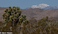
Entering Joshua Tree from the south introduces us to the
Colorado desert, a portion of the Sonoran desert. Here it occupies the area below 3,000’ in
elevation. We see mixtures of plants;
Palo Verde, Pencil Cholla and Brittlebrush to name a few. Other plants definitely live in specific
regions; Ocotillo, nonexistent during most of our drive through the park dominates
the landscape a mile or two along the road, then disappears. We stop for lunch under one of the larger
ones before continuing. We see the same
with Cholla cactus. The park service has
a designated ‘Cholla Garden’ along the road. There is parking lot and
signs describing the area. You can look
all you want but don’t touch, even from a distance their thorns look painful.
We climb out of the Colorado desert at 3,000’ entering the
Mojave desert. Here we see different
vegetation; Joshua Trees, Mojave Yuccas, Parry’s Nolina, Juniper and Scrub Oak. Even these seem to live in their own regions,
although less defined.
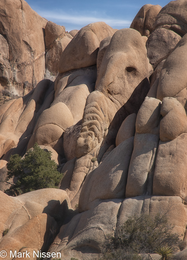
Rock outcroppings are different, they show up any and
everywhere. Over the millennia they have
been pushed up, broken into pieces while still under the soil then exposed by
erosion. Some of the outcroppings are
very organized; neatly stacked rocks/boulders beside each other; others are
random piles, while others are a mixture of both. Somehow small plants grow and flourish in little
more than a crack in the rocks.
Joshua trees are the reason we came here.
Many appear to have been here for hundreds of
years; old, scraggly, branches bent and twisted in odd directions – like they
have been through a war, their wounds still visible yet they are still growing. The Joshua Tree (Yucca brevifolia) is a plant
species belonging to the genus Yucca, not a tree at all.
 We hike several short trails. Our cameras and eagerness to photograph the
area hinders our long distance hiking plans.
The area is beautiful with plants nestled in around the rock
outcroppings while others stand out on their own.
We hike several short trails. Our cameras and eagerness to photograph the
area hinders our long distance hiking plans.
The area is beautiful with plants nestled in around the rock
outcroppings while others stand out on their own.
A few of the rock outcroppings are the center of attention
for rock climbers. We stop to watch
climbers scale up the 30 – 50’ walls. We
look at each other knowing this is just the starting point for the climbing we
will see at Yosemite.
 |
| Skull Rock |
 |
| Joshua Tree |
 |
| Nolina |
 |
| Elephant Rock |

Our last morning we are serenaded by a lone coyote, another
joins in, then a family of pups add to the song. A second chorus follows before falling back into
silence. Later, woodpeckers take over; drumming
on Joshua Trees searching for tasty morsels.
Los Angeles
We are on our way to Pomona to visit family and
friends. On our way we pass a huge wind
farm. Wind mills of many sizes face the
wind; small ones – spinning frantically; scores of medium ones, whirling in
unison; large ones– rotating gracefully.
 |
| Redondo Beach pier |
Traffic through LA comes and goes; large packs of vehicles
pass us; doing the speed limit does not seem acceptable. An empty hole ensues, a breather for the
driver, before the next onslaught of vehicles.
Over the 90 minute drive in LA we are forced to slow down not more than
a handful of times. I found a RV park in
Pomona near the fairgrounds. Not our
idea of a camping spot but we are pleasantly surprised by the amount of green
space and a lake. The place is packed
with campers upon our arrival with more arriving and setting up as we enjoy our
lunch.

Sequoia, Kings Canyon NPs
We face heavy winds again ascending north out of LA towards
Sequoia NP. Turning off the main highway
in Bakersfield we are on a two lane highway for the balance of our day. The terrain, mainly flat is filled with oil
pumping equipment. It is everywhere. I don’t think another piece of equipment can
be squeezed into the area. As we
continue the oil machinery disappears; orange groves taking their place. Occasionally a grove of bare trees fill the
landscape; almonds or pistachios? The
orange groves go on for scores of miles.
Some trees are more orange than green.
Climbing into the Sierra Nevada foothills the landscape changes to
natural flora; trees, shrubs, grasses and cactus.
 |
| Moro rock |
We are a bit early in the season for visiting this part of
the Sierra Nevada Mountains. Speaking
with a ranger we find out the main road between Sequoia and Kings Canyon has
only opened up in the past couple days. The
ranger informs us May and June are good times for visiting when all the roads
and facilities are open, later in summer one has to deal with the heat at the
lower elevations. During our visit we
see up to four feet of snow in some locations along the mountain top sections
of the main road.
From our campsite just outside the southern entrance of
Sequoia NP we begin our tour. The road
snakes along the foothills. A sign, past
the visitor center recommends that vehicles over 24’ should not proceed. Carrying tire chains is mandatory, (many
businesses in town have chains for rent).
Having measured our vehicle for our Alaska ferry ride in 2019 I know we
are only 22’ long. I count 13
switchbacks, close to 180° turns, ascending the mountains. This does not count the many easier twists
and turns we encounter. We reach the
crest at just over 6,000’. 50°
and sunny skies at our campsite cools to 30°. Snow still hiding in the shade at lower
elevations boldly piles up around us.
WOW! Is all we can say seeing the first sequoias. They are in an entirely different league of
trees. The red bark stands out, the look
and texture of the bark is different.
And the size; indescribable – WOW.
Along the mountain top, home to these sequoias, fog rolls in and out
making the whole scene surreal. The tops
of the trees disappear into the fog. Do
they really end there or is the fog hiding the real tree tops?
The Giant Forest Museum operating limited hours is closed,
so we walk; gingerly, along the ‘The Big Trees Trail’ instead.
 |
| General Grant tree |
It is covered by snow and ice hence the slow
walk.
Snowshoes or mini spikes would be
the way to go under these circumstances.
The second day we drive deeper into the park. The General Sherman Tree parking area is
packed. A line of cars sit and wait for
earlier visitors to return to open a parking space. We have another day to visit so we pass on
seeing General Sherman.
 |
| Hospital Rock |
Hospital Rock is in the lower foothills. A few pictographs are painted on one of the
large rocks near the river. Potwisha Native
Americans lived in the area starting around 1350.
 |
| Kings Canyon |
We make a loop route for our visit of Kings Canyon/Sequoia
parks. We head towards town, refuel,
then follow the backroads through more orange groves, into the foothills. The route twists, dips, and climbs giving us
brief views of the terrain. There is very
little traffic on the narrow, but scenic route.
Approaching Kings Canyon we climb higher encountering snow. Arriving at the visitor center parking lot we
see very few people and wonder if we are at the right location. Finally we spot the visitor center; it is buried under and hidden behind so much snow that we can see only small sections of the
building. The park rangers are happy to
see us. After one question of what there
is to see they offer many suggestions; General Grant Tree and surrounding
forest, Hume Lake which has only recently opened, and several overlooks along
the road. We do each; still amazed at
the size of the sequoias. We can only drive a few miles down Kings Canyon Scenic Byway before the road is closed, detouring us towards Hume Lake. We stop at a canyon overlook on the way to Hume Lake this appears to be the place where clouds play... We watched them form, swirl around the ridges disappear and reform elsewhere.

 |
| Hume Lake |
 |
| Hume Lake |
 |
Mountain top
road conditions |
 |
| General Sherman tree |
We follow General’s Highway,
the main road between Kings Canyon and Sequoia National Parks. It is 60+ miles long following along the top
of the mountains. Heavy fog moves in
causing us to slow our 25 mph drive to 15.
We can only see a few hundred feet in front of us for 10+ miles of our
drive. The fog is still thick arriving
at General Sherman Tree, the largest living thing on the earth. The line of vehicles is longer than we
encountered yesterday. Since this is our
last day we park at a wide spot in the road hiking back several hundred yards
to the parking lot and trail head. The fog
is so thick the tree appears like a ghost, revealing more and more detail as we
approach the massive trunk. We read that
some of the limbs, a few hundred feet in the air are over three feet in
diameter – a good size tree in itself.
Leaving General
Sherman the fog persists for the next several miles. It lingers on our initial descent off the
mountain finally disappearing at the foothills.
Blue sky finally appears the as we exit the park several thousand feet
lower than the cloud covered mountains.
On to Yosemite.
Thank you for stopping by,
Mark


 We hike several short trails. Our cameras and eagerness to photograph the
area hinders our long distance hiking plans.
The area is beautiful with plants nestled in around the rock
outcroppings while others stand out on their own.
We hike several short trails. Our cameras and eagerness to photograph the
area hinders our long distance hiking plans.
The area is beautiful with plants nestled in around the rock
outcroppings while others stand out on their own.


Beautiful!
ReplyDeleteI'm glad you could enjoy the story and photos
ReplyDeleteVery well written and the photos add to your description. Loved them.
ReplyDeleteLoved your description, Mark! Better than visiting these places:-) Three of them are fun to imagine:
ReplyDelete1) "Many appear to have been here for hundreds of years; old, scraggly, branches bent and twisted in odd directions – like they have been through a war, their wounds still visible yet they are still growing. "
2)"we are serenaded by a lone coyote, another joins in, then a family of pups add to the song. A second chorus follows before falling back into silence. Later, woodpeckers take over; drumming on Joshua Trees searching for tasty morsels."
3)"The campground is rocking, not from an earthquake; it seems loud music, and yelling are the way to have a good time."
Nature, animals and humans came to live under your pen:-) Thanks for a banquet of words!
Hi everyone, thank you for the nice compliments. I enjoy the writing almost as much as taking the photographs.
ReplyDelete